
Following a few easy days in the Santa Cruz area, we figured it was time for some hiking again, which is why we came to Altos de Lircay Reserva Nacional.
Following a few easy days in the Santa Cruz area, we figured it was time for some hiking again.
The reason we’d come to Vilches was its vicinity to Altos de Lircay Reserva Nacional, which features spectacular vistas over the valleys carved by 3 different rivers, Río Lircay being the biggest one.
On the way to our accommodation, we already noticed that something was going on. There appeared to be a haze everywhere. It couldn’t be fog because it was too late in the day. Opening the car window and having a sniff revealed what it was: smoke. More specifically, wood fire smoke – there was a forest fire somewhere upwind. At our accommodation, we asked our host about it, and she said that about 50 kilometres north (Agua Fría, Molina), there was an area of over 10000 hectares burning. It had apparently been going for a few weeks, but its expansion was said to be under control. Depending on the wind, they got either clear skies or smoke everywhere. Some evenings, they could see a red glow on the horizon. (CONAF, Chile’s park authority, provides info on current forest fires here)
We decided to go check at the park entrance if it was open and if so, if we could do the hike we intended to do. As it turns out, the park was open and hiking was allowed as usual, with the side note that the views would not be as good due to the smoke.
Back at our hostal, 25 minutes away from the park entrance along a road and some dirt tracks, we got served a home cooked meal on the patio. Hostal Macal is one of those houses that makes you wonder why you don’t live in the countryside – spacious, living room with a massive fireplace and lots of light through huge windows, big vine-covered patio overlooking the large garden with pool, and a backdrop of mountains just where the sun rises. I wondered how much it would cost.

We turned in early because we didn’t want to start our hike late. The next morning, we got a big breakfast, and set off for the park. The entrance we mentioned previously is actually nothing more than a place where they stop cars that aren’t 4×4 or don’t have a campground reservation. We had neither, so we parked up and headed in on foot. After 2 kilometres, you pass the park ranger’s hut, where you need to register your hike, and pay. The entry set us back 6000CH$ each, but we did get a good explanation from the ranger, who spoke English quite well. The night before, we had been trying to decide which hike to do – the options being El Enladrillado (a volcanic plateau overlooking a valley, 28 kilometres there and back, 1200 metres elevation gain) or Laguna del Alto (a lake inside a crater, 26 kilometres, 1100 metres elevation gain). The ranger said that the first was actually a bit easier despite being further and higher, and we figured that we’d have crater lakes when we get to Peru, and settled on the Enladrillado hike.
We signed a piece of paper confirming that we wouldn’t try to hunt any of the wildlife or try to set the place on fire, and set off. The first 9 kilometres were relatively easy, mostly through shady forest, but quite dusty. It was clear that it hadn’t rained in this area for a while, as every step threw up a little dust cloud, and started sticking to our shoes and legs, colouring them brown.

After these 9 kilometres, we got out of the trees and into a more barren landscape at about 1700 metres altitude. The next 4 kilometres were harder, climbing 500 metres on volcanic rock without tree cover, but we made it faster than we thought we would, even overtaking a group of locals (we usually only see them briefly as they sprint past us up the mountain).
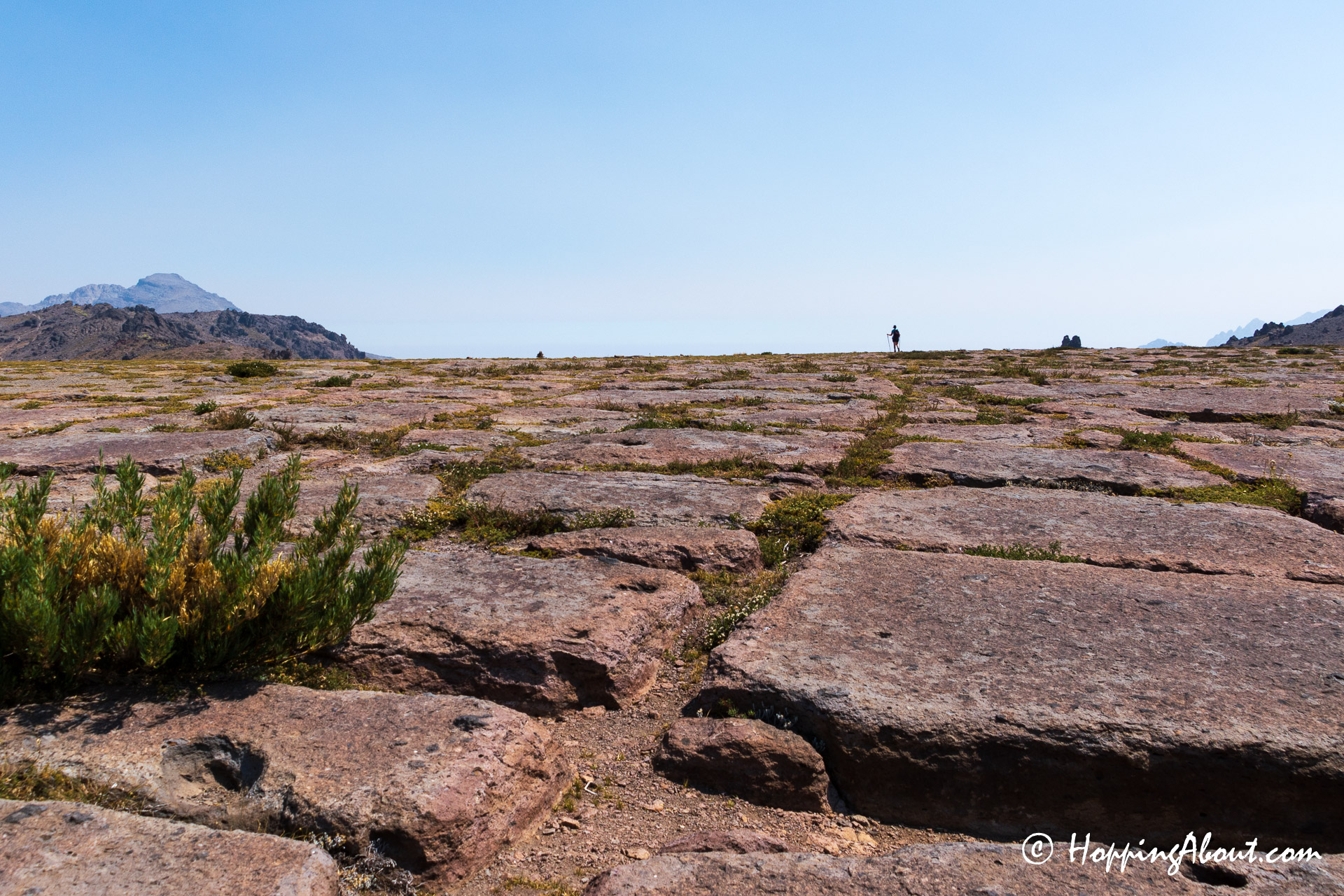
The first sight of El Enladrillado (meaning as much as paved, or tiled) was quite impressive. It is a big flat plateau that seems to have been made up of huge flat bricks, but these bricks are the result of volcanic activity. Beyond this plateau there is a very steep drop into an enormous valley with towering volcanoes on the other side. At least, that’s what we were told, since even though the wind had turned and there was noticeably less smoke than the day before, it still made the opposite side of the valley look very hazy.
The place was also teeming with wasps for some reason, and they were as keen to dig into our lunch as we were, so we didn’t linger too long. We entertained the idea of returning via Laguna del Alto instead of just going the same way back. That would have meant another 6 kilometres to the crater along the ridge, with little height difference, but then also a more treacherous descent. We hadn’t seen those trails yet, and we wanted to be back at the ranger hut before dark, so we decided to go back the way we came.
That was probably for the best, as even on the path we knew, I managed to slip and fall while holding my camera. I broke my fall with my free hand, which was also for the best, since hands tend to heal but cameras not so much.
After 13 kilometres of working our way back down, caked in various layers of dust, and with everything hurting at least a little bit, we made it back to the car with more than an hour spare until sunset. I tracked our route using Wikiloc, but had to stop it after 17 kilometres because my phone’s battery was running out, so what’s shown as the end point isn’t where we actually stopped.
A serious bit of scrubbing was involved to get all the dust off, and then a serious portion of spaghetti to fill us up, before we limped off to bed, ready to head for Santiago and Valparaíso the next morning.
Practical info
- If I had the chance to visit this place again, I would probably try to camp there. There is a decent campground at the 6th waypoint in the route above, about 9 kilometres in. Sleeping here would make it possible to make the trek to both El Enladrillado and Laguna del Alto, without having to redo the first section. You could probably also try to catch sunrise or sunset at either of them if you bring sufficient light.
- There were no restaurants open near the park or Vilches when we were here in early March.
- It’s easiest to get here by car, but there is a bus service from Talca. If you want to do one day here by bus, you’re going to need to be a very fast hiker if you want to do anything but the children’s trail because buses don’t run very late: